
Forecasters at the National Hurricane Center (NHC) expect Isaias to restrengthen into a hurricane off the South Carolina coast later today and the storm could make landfall in the Myrtle Beach region tonight.
As of 5 p.m. Monday, Isaias was spinning about 60 miles south-southeast of Charleston,South Carolina and 120 miles south-southwest of Myrtle Beach, South Carolina with maximum sustained winds of 70 mph moving at speeds of around 13 mph.
Around 3 p.m., a wind gust of 52 mph was reported at Folly Beach, according to the National Weather Service.
A hurricane warning is in effect for coastal Georgetown and Horry counties while a tropical storm warning is in effect for coastal Beaufort, Charleston, and Colleton counties. A storm surge warning is in effect for all coastal areas north of Edisto Beach, South Carolina.
“Some strengthening is forecast later this afternoon or early evening, and Isaias is expected to make landfall tonight at or near hurricane strength along the coast of northeastern South Carolina or southern North Carolina,” the NHC said in its 5 p.m. update.
The storm system could make a landfall north of Myrtle Beach, around the SC-NC state line.

Finally, the spaghetti models have mostly aligned, here’s a look at the latest track.

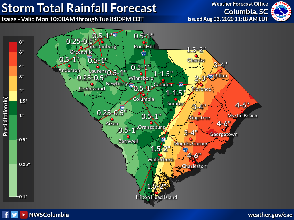
Rainfall/ Flooding
Georgetown and Myrtle Beach should expect to see 4-6 inches of rain from Isaias later today.
Here’s a look at total rainfall amounts across the east portion of the state:
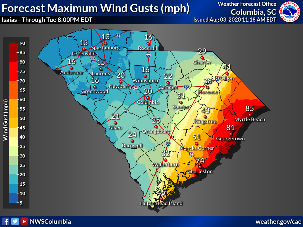
Wind
On the S.C. coast, the Hilton Head region has the lowest chance of seeing tropical-storm force winds, and those chances increase northward with Myrtle Beach having the best odds.
![[Image of probabilities of 34-kt winds]](https://www.nhc.noaa.gov/storm_graphics/AT09/refresh/AL092020_wind_probs_34_F120+png/092753.png)
The Grand Strand area has about an 80-90 percent chance of seeing tropical-storm-force winds today, while the Lowcountry has a 5-20 percent chance.
Isaias has a fairly large footprint with tropical-storm-force winds roughly 125 miles its center.

The coastal Myrtle Beach area could see hurricane-force gusts up to 80 mph most likely later tonight.

There is also a threat of tornadoes, especially in the Myrtle Beach area later this afternoon and evening.
Rip current warnings remain off the entire South Carolina coast as forecasters warn to stay out of the water today.
Here’s the full update from NWS- Charleston (showing Hilton Head, Colleton County and Charleston forecast)
Here’s the full update from NWS- Wilmington (showing Myrtle Beach0Georgetown forecast)
Here’s a look at Hilton Head around 10 a.m. as Isaias moved closer.
Around 3 p.m., it approved conditions were improving on Hilton Head.
It appears that Charleston, Hilton Head, and Beaufort got lucky and were spared from most of the storm. Stay tined..

*****
ABOUT THE AUTHOR..

Mandy Matney is the news director at FITSNews. She’s an investigative journalist from Kansas who has worked for newspapers in Missouri, Illinois, and South Carolina before making the switch to FITS. She currently lives on Hilton Head Island where she enjoys beach life. Mandy also hosts the Murdaugh Murders podcast. Want to contact Mandy? Send your tips to mandy@fitsnews.com.
***
SOUND OFF…
Got something you’d like to say in response to one of our articles? Or an issue you’d like to address proactively? We have an open microphone policy! Submit your letter to the editor (or guest column) via email HERE. Got a tip for a story? CLICK HERE. Got a technical question or a glitch to report? CLICK HERE.
