
The latest projections for Hurricane Florence show this potentially devastating tropical system drawing a bead on Wilmington, North Carolina – however all 187 miles of South Carolina’s coastline remain inside the storm’s five-day forecast bubble.
That means the Palmetto State is still very much in the danger zone for a direct hit from this storm – which is forecasted to begin undergoing “rapid intensification” this week as it churns toward a late Thursday or early Friday morning arrival on the east coast as a major (i.e. category three or stronger) hurricane.
“Rapid intensification is likely to begin by tonight,” warned the latest advisory from the National Hurricane Center (NHC) in Miami, Florida. “Florence is forecast to become a major hurricane on Monday.”
As of early Sunday, though, Florence was still a tropical storm packing maximum sustained winds of around 70 miles per hour – with storm-force winds extending outward up to 125 miles from her core. Weakened in recent days by vertical wind shear – which flattened the system and disrupted its center of circulation – Florence will enter calmer, warmer waters over the next 48 hours.
Those conditions will fuel its resurgence, at which point the guessing game begins over where it will go.
Located 765 miles southeast of Bermuda, Florence is moving west at around six miles per hour. That movement is expected to continue throughout the day on Sunday.
“A west-northwestward motion with an increase in forward speed is expected by Monday, and that motion is forecast to continue through mid-week,” NHC forecasters predicted.
Here is the NHC’s latest forecast bubble …
(Click to view)
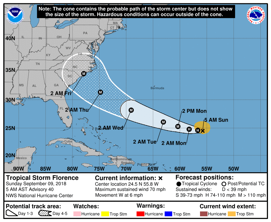
(Via: NHC)
And courtesy of BoatUS.com, one of our favorite storm-tracking websites, here is its latest projected forecast track …
(Click to view)
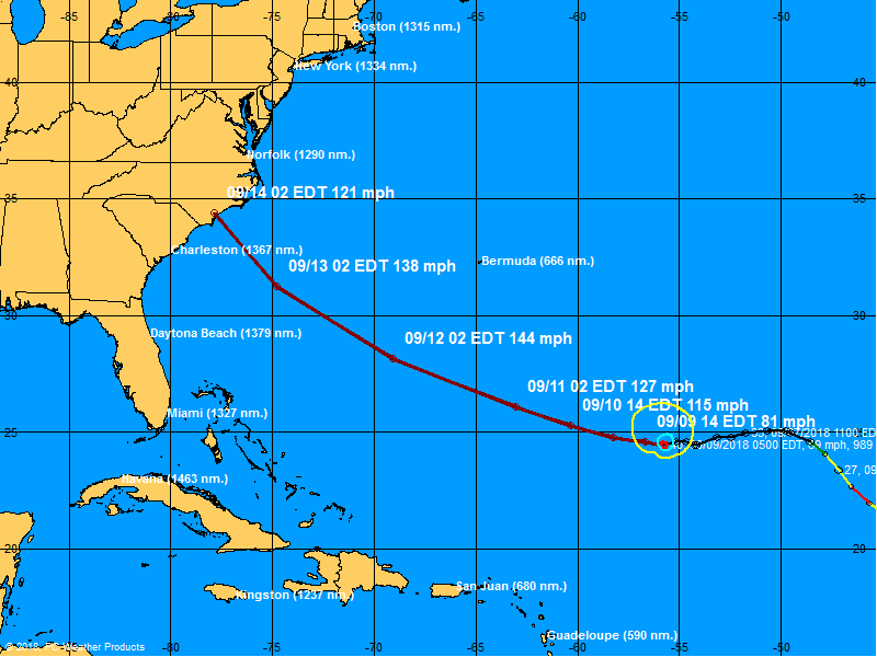
(Via: BoatUS)
Obviously this latest tracking suggests that Florence will take a path pushing likely landfall further to the north – although as we noted in our original reporting these tracks change every few hours based on new information.
Still, the latest models are modestly better for South Carolina. Yesterday, data pointed to a landfall smack dab in the middle of the Palmetto coastline between Charleston and Myrtle Beach – near where category three monster Hurricane Hugo, roared ashore back in 1989.
Such a direct hit could be cataclysmic … and remains very much a possibility based on current forecasts.
The first major tropical system of the 2018 season, Florence will be watched closely over the coming days as it builds back up and begins its approach to the east coast. This news outlet will continue to keep a close eye on the system’s movements and provide our readers with regular updates.
As we have noted previously, we would encourage readers to download the 2018 South Carolina Hurricane Guide (.pdf), published by the S.C. Emergency Management Division (SCEMD) and to start familiarizing themselves with evacuation routes in the event that becomes a necessity in the coming days.
[timed-content-server show=’2018-Jan-17 00:00:00′ hide=’2018-Oct-22 00:00:00′] [su_dominion_video] [/timed-content-server]***
WANNA SOUND OFF?
Got something you’d like to say in response to one of our stories? Please feel free to submit your own guest column or letter to the editor via-email HERE. Got a tip for us? CLICK HERE. Got a technical question or a glitch to report? CLICK HERE. Want to support what we’re doing? SUBSCRIBE HERE.
Banner: NOAA