
STORM THREATENS NORTH CAROLINA’S OUTER BANKS …
Tropical storm Arthur – the first named system of the 2014 season – is gaining strength as it moves up the east coast, prompting officials in North Carolina to take action in anticipation of a soggy, windy Fourth of July weekend.
In fact N.C. Gov. Pat McCrory has declared a state of emergency in twenty-five counties – activating the National Guard and preparing resources to respond to the storm.
“While we all want to enjoy a fun Fourth of July weekend with friends and family, our highest priority should be safety during the storm,” McCrory said in a statement. “I encourage all of our coastal residents and visitors to take necessary precautions, listen to local media and use good judgment throughout the duration of the storm.”
Currently 100 miles off the coast of Cape Canaveral, Florida, Arthur is packing maximum sustained winds of sixty miles per hour (as of 2:00 p.m. EDT Wednesday afternoon).
“Arthur is expected to become a hurricane by Thursday,” the latest advisory from the National Weather Service (NWS) predicts.
Tropical storm watches have been issued for the coast of South Carolina, although current forecast models call for the storm to turn to the northeast in the coming days – bypassing the Palmetto coastline altogether. In fact South Carolina is completely out of the official five-day forecast window from the National Oceanic and Atmospheric Association (NOAA).
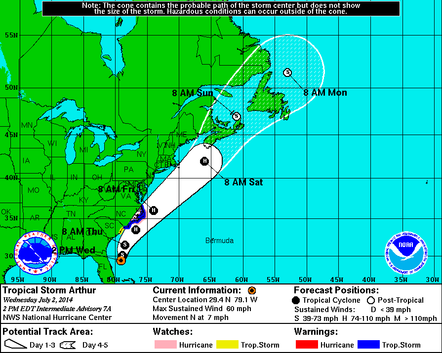
Take a look …
(Click to enlarge)
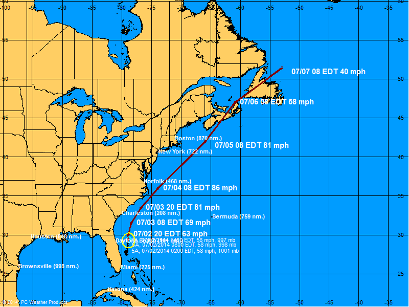
And here’s the storms current forecast track …
(Click to enlarge)
We’ll continue to keep track of Arthur as he makes his way up the coast …
(To read our previous coverage of Tropical Storm Arthur, CLICK HERE) .
4 comments
Arthur bees got him a stiffy and lookin for somebody to blow. Grab yo buttcheeks and hold on tight.
First a bridge, now a hurricane?
We need another ice age, bet you never heard of anyone complaining about hurricanes durning the last one.
TBG’s Eco-friendly, HI-DEF, sodium and gluten free, Super Doppler, VIPER, 360 degree, polarized, oscillating, wireless, mobile, MOS-DEF, green, NOAA licensed, nanotechnology driven, diverse, OSHA approved, 32 bit, mega-giga-terabyte, integrated, non aerosol, solid state, WIFI compatible, plasma, sustainable, ultra sharp, razor thin, flat screen RADAR storm tracker (with FUTURECAST) platform oscillates between prediction #1:
Breezy, with some rain east of the I-95 corridor. Get stoked for some decent [East Coast] surfing from the Washout all the way up to Nova Scotia . South Carolina fishermen should stay inshore for the next 48 hours.
…and Prediction #2:
EAST COAST DISASTER OF BIBLICAL PROPORTIONS!!!!!! OUTER BANKS WILL BE WIPED OUT! DEATH! DESTRUCTION! KATRINA! HUGO! SANDY! MAN-MADE CLIMATE CHANGE! TORRENTIAL RAINS! WIND! STORM SURGE! RIP TIDES! SAVE YOURSELVES! EVACUATE NOW!!!! AAAUUUUURRRRRGGGGGGGGGHHHHHH!!!!!!!!!!!